Fleuves en
Confluence –Soyez Prudent - Candes-St-Martin and Montsoreau 5th May
The Loire was in a rough mood as we followed the road along the top of the floodbank on the north side and crossed the bridge near Montsoreau. The water brown and turbid, current still strong, swirling under the bridge. It was also choppy and agitated, with waves, by the strong westerly wind funneling along the valley from the Atlantic.
Just downstream of the bridge, power lines crossed
the river, emanating from the Centrale Nucléaire upstream. Two large red and
white striped double pylons, on either side. Spheres at intervals along the
power lines to “remind birds” flying above the river.
Across the bridge, we passed troglodyte dwellings in the cliff on our right, then turned right at the
T-junction and parked in a car park close to a metre wide stream, still running quite fast after the rain. This was the Arceau which rises near Fontevraud and the Abbaye Royale which we were to visit the following day. After crossing the road, we took a lane up the hill signposted Moulin de
Tranchée, our walk to the Panorama roughly following the GR3 route eastwards along the
tuffeau ridge. Further up the hill, the path opened out, with large tuffeau
pebbles beneath our feet. Ahead of us uphill was the Moulin de Tranchée
windmill, set on the edge of a vineyard. It looked slightly foreboding against the changing cloudscape behind. Turning left near the
windmill, we took the path through the vineyard, vines at this time of year
freshly in leaf. Views back to the windmill and westwards along the still very
choppy looking Loire and the road bridge. Near here too, our first views upriver to the Centrale
Nucléaire de Chinon nuclear power station came into view. Twin masses of cloud
from the cooling towers rose to mingle with the still fairly low level cloud
base.
After the vineyard, a more fiddly mix of paths and
lanes, though everywhere fairly quiet. We took it a fairly slow pace, enjoying
garden flowers (irises), buildings etc. The final stretch, along a narrow lane
near a farm, took us up to the Panorama overlooking the Loire-Vienne
confluence.
The Confluence
The Panorama / viewpoint was in an open green area on the hillside above the confluence. Near
the centre was, a semi-circular turret housing a board pointing out the landmarks,
mainly looking east, in French and English. The land around the confluence on the nearside very wooded, everywhere a verdant green. There were several handy benches for my energetic sketching, and lunch. I did three very rough, fast-paced drawings, having to watch that my sketchbook didn’t blow away in the wind which was particularly strong here. A long line of cloud ran above the Loire. The (la) Vienne was at the foot of the hill, coming in from the south, spanned by a road bridge, crossed by cyclists in bright red / orange tops. There were several handy
benches for my energetic sketching, and lunch. , slope down towards the
wooded steep slope. Carl saw some orchids.
Did three very rough, fast-paced drawings, having to watch that my sketchbook
didn’t blow away in the wind which was particularly strong here. A long line of
cloud ran above the Loire.
At the turrent a bit of information about both rivers, both brown and turbid looking and fairly high with the sandbank at the apex of the join completely covered, though the Vienne was the calmer of the two.
The power station among the landmarks,
being harder to hide here than at Saumur, even though they’ve reduced the height of the
cooling towers to 30m “in respect of the surrounding countryside”. Apparently,
it was the first nuclear power station to be built in France, in 1957. It’s been operating since 1963. It uses water
from the Loire to cool the pressurised water reactors . The French have always
been particularly big on nuclear power, still generating 70% of their
electricity. There are four nuclear power stations along the Loire, though I
think this one has the largest capacity. The
Vienne – chocolate brown is the Loire’s
biggest tributary. It is slightly longer than the Severn, 354 km (220 miles).
https://fr.wikipedia.org/wiki/Vienne_(rivi%C3%A8re_fran%C3%A7aise)
Along the
Loire through Candes-St-Martin and Montsoreau

From the panorama, we took a path / track down the
hill which brought us out on the north side of the hill near the church at
Candes-St-Martin. Seemingly yet another landmark in the Loire valley undergoing
extensive repair and maintenance. Much of the slate roof was covered in
scaffolding, as was the tuffeau wall beneath it. There were vertical cracks
between the stonework along one of the walls near a side entrance. We had a
quick look round inside which was fairly plain and simply furnished. Comparing and contrasting the condition of the stonework
inside and out showed all the more reason for the restoration work. Inside,
protected from the weather, the dressed stone blocks, even more so the stone
carved figures, bosses etc were in near-perfect condition. Outside, exposed to
the elements - especially rainwater which is naturally mildly acidic and reacts
chemically with limestone (calcium carbonate). Some of the figures near the
north doorway outside were missing heads, though hard to tell whether this was
weathering again or deliberate sabotage / desecration.
We then walked along the narrow lane at the foot of
the hill, parallel to the Loire. Just south of the church was a small area of
quay alongside the river, with a couple of flat-bottomed boats moored, one of
them had water in and didn’t look water worthy without bailing out or patching
up the leaks. Though the waves were easing off with the drop in
wind speed, the water still looked rough. A view back upriver towards the
confluence. The Vienne was still making its mark well downstream of the
confluence: a subtle change in the tone of the turbid brown water, looking
northwards straight across the Loire, the on the nearside slightly darker.
A tree trunk on the submerged sandbank at the apex of the confluence, a cormorant
perched on it. About six feet up the wall to our right was a floodmark dated1982. This had been another turbulent floody time with several floods along the Loire and the Seine between January 1982 and May 1983, but I took it to be the December - another tempête / crue de Noël. There was another of those deep low pressure systems bringing lots of rain, like Tempête Dirk in 2013, though it had been a wet winter in northern Europe generally. Much of the flood input came from the Vienne.
Les grandes crues de l'hiver 1982 et du printemps mai 1983
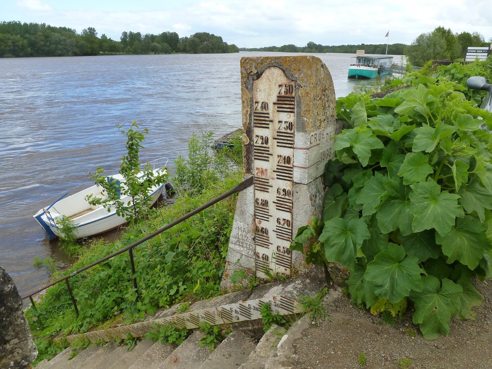
Leaving
Candes and entering Montsoreau, the riverside opened out. Just past the
houseboat were steps down the levée, doubling up as a height gauge.
Measurements in metres relative to the base summer level of the Loire. The top
of the steps was at about 6.5m. They still needed another metre of post at the
top to accommodate the big ones. The three biggest historical floods were
during the middle of the nineteenth century: 1846, 1856 and 1866. Nearly didn’t
see it with the vegetation, but both the latter two were marked on the south
side of the post (facing the road). Both were over 7m, 1856 was the very big
one. 1866 not far below it.
Montsoreau
Château
Reached by crossing the road along the river and
going up the hill and round onto the grassy area round the back, where the moat
would have been. Entry was 9.20 each, this would also get us 30% off our
tickets for the Abbaye Royale at Fontevraud on Wednesday. Though I’d longed to get back to the Loire valley, when it came to the châteaux, I hadn't been that bothered. I don't tend to do stately homes back home and I tend to prefer ruined castles for their artistic atmosphere to intact, furnished ones. This one, though was a particularly good. Not just for the views along the Loire back to the confluence and downstream towards Saumur, or the troglodytes in the cliff to the south, but the Son et Lumière – interplay of sound and lighting
effects - and related galleries inside. The focus was very much on the river, starting with the son-et-lumière display in the basement beneath the east wind, about the sailing barges which plied the Loire until the late nineteenth century. I thought it was beautifully done, the lighting effects evoking the
changing colours of the water.
It’s sad in a way that navigation along much the Loire came to a stop. Until the nineteenth century it was a major trade route in western Europe. Now it
is officially navigable for about the last 35 miles down from Nantes where it is tidal, though there are still smaller boats, a few pleasure boats (such as the one we saw at Saumur on Sunday), some houseboats at Montsoreau and Saumur, fishing boats. I gathered, too from the chateau displays / photographic exhibition in the south wing that they are trying to recreat some of the sailing barges out of historical interest. We saw one at Gennes (see later) later in the week.
The decline in commercial navigation came
during the C19th, for much the same reasons as British waterways fell into
disuse from that time: the coming of railways, followed by roads. The Loire’s
temperamental regime made it harder. Before the arrival of
steamboats, sailing against the current could take several days
longer than going with it. Keeping a navigable channel open during dry spells
required a lot of work.
The present level of navigation with pleasure boats, a
few small barges, etc is all good, but really it’s refreshing to see a river
free of bigger modern boats and everything that goes with them. All the more if
opening up navigation meant building large dams which would wreck the character
of the river completely, noise, pollution, increased crowding, the visual
intrusion. From catching the odd TV advert, I get
the distinct impression that every other big boat on the Rhine and Danube is an industrial size cruiser. Some of the sea-going cruise ships, including the Queen Mary 2 were built at St. Nazaire at the mouth of the Loire. They are
now a key feature of Southampton, but globally, they can be a visual intrusion in small ports or off small islands.
La Vienne at Chinon - 7th May
The
Loire looked calmer today with the lighter winds, brighter weather. Water much
more reflective. Water level now falling slowly and looking a better colour in
the sunshine, though on the way back from Chinon, noticed swirling currents as
we crossed the bridge near Montsoreau which made it look rougher than those
we'd seen on the Vienne at Chinon. Take it that a slow rise in water level over
days is melting snow, a rapid rise - seemingly within 24 hours at Saumur last
weekend - is run-off along the main river and its larger tributaries after
heavy, prolonged rainfall. See why they built the big (10m above base summer
level) levées, like the one the road we took today ran along. Village on right
bank near the cottage and facing Ile de Millocheau called St. Lambert des
Levées.
On
the way to Chinon along the north bank of the Loire and across to Montsoreau in
the calmer weather this morning, the cloud base at cirrus level, the cloud
generated by the cooling towers of the nuclear power station was much harder to
miss. We saw them from the tuffeau hills on Sunday and Tuesday, upriver in the
distance, but then the cloud base was much lower. This morning, there were
three pillars rising vertically then, on meeting higher level winds, they took
a ninety degree turn north, merging into what looked like a giant mouse like
animal in a long pair of trousers, extending two legs down to the ground, then
once across the bridge and us having seen its reflection in the river, it put
down another leg. When we got to Chinon, it lost the legs and became more
rounded and a bit less obvious as cumulus billowed up naturally and it became
cloudier generally. Even so, looking across the Vienne to the chateau, it was
there to the northeast, still looking different from the natural cumulus.
Leaving
the road from Montsoreau towards the abbey, took a D road up the hill above
Cande St. Martin and came down to a road south following the Vienne for a
while. Glimpses of it through the trees. Verdant woodland. Everywhere looking
lush.
Satnav
tried to direct us onto a cycle path at one point, but otherwise a smoother run
in on the south side of the Vienne, avoiding the busy town. Found parking near
a campsite just upstream of the bridge named in honour of Eleanor of Aquitane.
Crossed
over this bridge and walked up to the château. The Vienne was still looking
very brown, a chocolatey brown. Near the bridge it had a strong, swirling
currents, though generally, it had a more tranquil feel to it than the Loire.
Its width was on a more English scale. It's about the same length as the
Severn, though it has a bigger catchment size, boosted by La Creuse and its
affluents. When the Vienne is lower here, it has sandbanks like the Loire. A
small island, Île de Tour, where the bridge crossed.
Town
busy, with a sense of things building up for the second French bank holiday in
a week, this one commemorating VE Day. Quieter up hill near the château,
reached via the tree-lined slope above the town. Found the entrance and had a
look round, €8.20 each.
The
château here is the Fortress Royale. It had close associations with the
Plantagenets and Joan of Arc, who helped boot them out of France and replace
them with King Charles VII and end the Hundred Years War. Building of the
fortress began at the beginning of the C12th. Added to in stages after that by
John Lackland and Philippe Augustus? Also associations with the legend of King
Arthur and his Knights of the Round Table, something bigged up for the kids in
the form of a mock round table, dressed up statues to stand behind etc.
Mention, too of the Monty Python and the Holy Grail which sent up the King
Arthur thing. Particularly after being reminded of that, both found it hard to
take things too seriously, keeping our voices down in case any fellow Brits
within listening distance. All the more as we entered through the gateway in
the clocktower just as Joan of Arc would have done, only she was on horseback.
Above the path here, someone trimming the hedge. The sound of hedge trimmers
against a weird combo of background sounds playing on loop. I suppose this was
to suggest the sound of horses' hooves on cobble, followed by a fast paced
gallop through the gate. It sounded to me like wellies squelching through boggy
ground, or toilets flushing. Then, to the rousing instrumental heard time and
again as we looked round, I mentally added calls of La Loire, la Loire, la
Loire! Mental picture, too, of toilets flushing, remember Friday afternoon
silliness in Heath End French lessons during the period a supply teacher sat in
while the usual one was on maternity leave - the sea, the beach and toilets
flushing. Shortly after this we climbed the steps up to the various floors of
the clocktower, noting a bath / washroom / laundry prior to the modern luxuries
of piped, warm water and washing machines. A washing line with pants on. Several
rugs made from skin of wild boar, deer, with head, legs, hooves still attached.
Walking
back through the town at the foot of the hill, spotted a newsstand headline
outside shop with words "regime sec". Two or three words above it,
which I can't remember, implied something happening to bring on some sort of
regime sec, but don't know whether this meant a meteorological / synoptic
switch back to drier weather, a seasonal drop in water level after being up
more than a bit this week - they talk of the Loire's very varied / capricious
flow regime. Or could simply be an annoying political metaphor.
Took
the audio-visual sequences about Richard the Lionheart and Joan of Arc more
seriously, though still found Smiths lyrics intruding, the ones involving
the grisly death of Joan of Arc, albeit
with 1980s mod cons, "As the flames rose to her Roman nose and her walkman
started to melt". A room later on with various depictions of Joan of Arc
through the ages from around the world, including US ones ref WWI. Also a statue
of Joan of Arc in the town. As we share a first name, Carl thought of
photographing me standing by it, only to be disappointed when we found it
surrounded by a car park and market stalls at the bottom of the hill when we
walked round the town later on.
Around
the wall of the fortress, several towers to look round. The watchtower had
stone carvings of dogs looking down from the roof area, though this was not the
Dog's Tower, named after C15 kennel for hunting hounds, but was actually used
as a kitchen. a table packed with replica food, sausages, ham etc. hanging
above it. From the towers along the main wall along the west side, views down
to the town and along the Vienne. Two more distant bridges - a railway bridge
reflected in the water to the south. To the north, the road bridge we went over
by mistake trying to find a way into town, but sat-nav mistook cycle path (no
turn onto) for road.
Lunch
on deckchairs on the green area in the centre of the fortress.
Leaving
the fortress, we had a look round town. Square filled with people wining and
dining on big lunches. Road we took south took us to a residential area, which
was a bit tedious. Made our way back into the centre then crossed back over the
river to sketch the view of the fortress reflected in the water. Saw a family
of ducklings for the first time this holiday, the Loire clearly too much for
them until it drops back down.
Before
leaving, crossed back over the Vienne and strolled along it towards the railway
bridge beneath an avenue of trees. People playing petanque. Funfair being set
up. An strange performance from someone up a tree in black robes, speaker
attached to laptop playing soundtrack. Some guys with tattoos, fairground guys
I guess though seemed easier going / less rough than the ones we get in
England. "Ici la Vienne", one of them said to his toddler as they
watched the river, or even better "Vive la Vienne".
No Parking in the Whirlpool - Reserved for Fire Crews
On the way to Gennes, place names indicative of
straddling a big floodbank: St. Lambert-des-Levées, then St. Clement-des-Levées.
I suppose this was because the road was narrower than near Saumur, but we were
particularly aware here of driving along the top of a big, relatively broad
floodbank and the height of it above river level. Saw more of the river on the
way back, the lanes of the carriageway dividing through the villages.
When we got to Gennes, we crossed over the Loire on
a suspension bridge, the Île de Gennes here dividing the channel in two.
"Strooth, la Loire!", I called out as we crossed the bridge and I saw
the current. Just across the bridge on the left bank, turned right into a
picnic area by the river and parked. Sat on one of the seats, had an early
packed lunch and sketched. There were several boats moored on the nearside,
including a flat-bottomed sailing barge in the style of some of those described
at Montsoreau. to our right, the bridge
and a cobbled slipway sloping down to the water. Lower down a signpost
partially submerged; all the signs above water, the lower just about. The top
one a round no parking symbol, reserved for pompiers (firemen), though the
water still had a good metre or so to fall before they could even think about
it.

I thought the day before that the Loire was calming down
and we'd seen it at its roughest on Tuesday. Here, though, the current was
particularly fast and it was so turbulent on the downstream side of the bridge
that it was generating a whirlpool, or at least a very powerful vortex 3 or 4m
wide. I don't know whether this stretch of river was a particular pinch point.
Bridges usually are and I'd guess the eddy we saw was where it was flowing over
the partially submerged base of the nearside bridge pillar. Even allowing for
the Ile de Gennes, it looked a bit narrower than at Saumur. Don't know what
might account for that. Still a while to go (south of Angers) before it hits
the harder rock of the Amorican terrain. Different land use, partial silting up
of the channel here? The arm facing Gennes was slightly narrower than the one
between the island and the right bank, but even there, the current was strong -
compare with the Vienne yesterday at Chinon where it was swirling around in the
middle of the channel, where it's deepest and the current usually stronger, but
nearer the banks calm.
I don't know whether the effect of snow melt has peaked.
The water level has definitely been falling slowly but surely. Coming here
along the road, I noticed earthy banks reappearing on the far side. I think it
may even have dropped 2 or 3 centimetres while we were here at Gennes.
Beneath the bridge pillar, a depth gauge going up to
5m, presumably measured from summer minimum. Facing the car park, an info board
about flooding, noting particularly December 1982.
Meanwhile, the village of Gennes, built on a hill
above the river, was quiet on what was lunchtime on the French VE Day
anniversary bank holiday. Outside the church, we saw the memorial to the Saumur
Cavalry soldiers who tried to stop the Germans crossing the Loire in June 1940,
though the river view from here was largely blocked by the recent anti-social planting
of evergreens in the adjoining garden. The amphitheatre took time to find and,
when we did it was, unfortunately closed.
I'll end with links to some interesting videos I came across youtube I came across after the holiday, produced by Ce n'est pas sorcier. I like their zaney approach, the grue des crues sticking in my mind particularly:
 See my Water and Art blog for the series of sketches I did in the area around the East Pier.
 The timings of supermoons, lunar eclipses and predicted tide heights follow a roughly nineteen year (18.6y) cycle governed by the elliptical orbit of the Moon around the Earth and its position in the plane of the ecliptic, the Earth's orbit around the Sun. This goes some way to explaining the run of high spring tides during the past two years which have made for some good Severn Bores and high tidal ranges around the UK coast. However, the weather makes a big difference. This two year period has included some storms and tidal surges leading to widespread coastal flooding. Most notably: December 5th 2013 (North Sea), early January and February 2014 (both mainly affecting western coasts facing towards the Atlantic. All these episodes involved deep low pressure systems with less air pressing down on the sea making for a higher tide and strong winds. This time, the EA had a few precautionary flood alerts out for low lying and exposed areas of coast around England and Wales, along with the tidal Severn, Wye and Thames. The potential for tidal trouble, however, was very much moderated by high pressure over the UK and Scandinavia, a steady 1035 millibars on Sunday and Monday where we were in south Hampshire. Higher atmospheric pressure pressing down on the sea would reduce the tide height from that predicted, 20cm for 1035 millibars (Port of Southampton tide tables). Anticyclones, too make for light winds or still conditions.