The Lavant valley - Saturday 24th June
From Chichester, a circular walk to East Dean, via East Lavant, The Trundle via Chalkpit Lane,
Goodwood Road, Monarch’s Way down to East Dean. Back along the Lavant valley to
Charlton and Singleton. Up the hill from Singleton church. Back via Hayes Down
and the Centurion Way.
In a change from last week's heatwave, the day started with drizzle, light rain on the way out of
Chichester to East Lavant. The Trundle foggy, with low cloud, and no view at all from the top. After coming down the west side of the hill and crossing Goodwood Road, the stretch of road walking near / past the racecourse,
a bit of an obstacle course. There was a high-class do on in the posh grandstand reception
area, but the large areas cordononed off opposite the grandstands was most likely in preparation
for the Festival Speed next weekend. Essentially that takes over the whole area, leading to widespread, lengthy traffic queues. If not going to the event, the whole West Sussex area best avoided by road while it's on. Given the jams, the festival has always seemed
ironically named.
My main issue now was, something I’d
forgotten about amid of the dry weather: feet / trouser bottoms wet, thanks to wet
long grass, even if soil very dry and much of the grass browning. Worse than
usual as feet and socks wet through, thanks to trainers well on their way out and overdue for replacement.
Followed Monarch's Way along road east
to where it turned left off the road to go down the north side of the ridge to
through the woods to East Dean. The last bit out of the woods near the foot of the hill
to the lane down to East Dean, over stile very overgrown, long grass alongside
barley field.
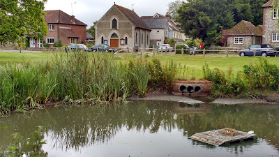 |
| East Dean pond |
Lunch on the village green, by East Dean pond. There was still water
in it, though very meagre, with bare soil around the sides. The River Lavant
,
which rises here, Needlesstosay
, dry everywhere.
Began the return leg of the walk along the valley of the absentee river to Singleton. Along the road to Charlton, most of the traffic seemingly bound for, parked by what a took to be the Charlton gastro pub. From Charlton, left off road, through field to Singleton. Path overgrown where it left the field at the western end at end. Very long grass, though by now dried out, hill clear now, too. Uphill from Singleton church to Trundle.
Back down to Chichester via Hayes Down, sat over looking the view across the valley below West Dean. Of all the views along the South Downs, this is the one I've probably sketched the most times, upteen times during the past eight years. In winter, usually water in the stream running across a large field below the main road, crossed at the southern end by the Centurion Way cycle path coming down from the road before turning south. Before following this path back into the city centre, I had a quick, closer look down there. Compare and contrast photos of the dry riverbed now with the same view during the ages of abundance, which began with the unusually wet, recharging spring and summer of 2012; and included winters 2012/13 and 2013/14. Groundwater flooding on the road in East Dean, pumps at Singleton.
Dry river bed of the Lavant below West Dean
Then and now photos from winters 2012/13,
2013-14 Groundwater flooding around East Dean.
 |
| Along the Centurion Way above Mid Lavant |
During the hour+ walk back into the city centre, I contemplated the missing / missed River Lavant. A
misfit stream in a misfit climate; and misfit theories attempting to explain them. As noted by Ken Newbury
in his book on the Lavant
published in
the 1980s (revised 2000 to include pictures of the 1994 floods), the
theory goes (back to about 10Ma BP)
, that the proto
-Lavant
would
have run from south to north, like the Arun
, draining off the Wealden
anticline. As that eroded, the South Downs chalk escarpment (and the Hangers
escarpment to the W, the N Downs escarpment to the north) would have pushed
back, exposing the Gault
Clay below, and below that Lower Greensand
. Once the
latter was exposed, a proto
-Rother
(probably starting off flowing into the Arun
east of
Midhurst
) cut back westwards through the sandy layers and captured the upper
reaches and headwaters of the proto
-Lavant
. The East Dean – Singleton stretch
of the now Lavant
would have been a tributary to the larger river. As the BGS
maps show, the now upper Lavant exploits a fold – a syncline
, Singleton Anticline to the north,
with Levin Down. The only thing is, the gradient north of the escarpment at
Cocking is now in the wrong direction. The brook fed by springs at the
Chalk-Gault
Clay line, Costers
Brook, flows north to the Rother
. Can’t see any
other way through the Downs other than where the A286 now goes through. Leaving
Singleton to head north, that immediately goes up hill. Maybe surface
topography / local gradient has changed through erosion. The beds dip south.


