Wednesday, July 1, 2015

La Loire Vivante - Part 1

Around Saumur

We arrived in Saumur around 11:00am on Saturday 2nd May, two unseasoned Brits abroad speaking very bad French, worse for our estuary English accents. We were disorientated and punch drunk after an overnight ferry crossing with patchy sleep and a much earlier start than we’re used to for the drive south from Ouistreham. Leaving the autoroutes and coming to Saumur from the north, we crossed the Pont des Cadets de Saumur and came to a broad but busy street, though this wasn’t the main town. We were on the the Île de Millocheau, one of the numerous islands in the Loire. We then, though came to the main river channel, the wider one, crossed via the Pont Cessart to the main town, built beneath a ridge of limestone. After a smooth, blissfully quiet journey along the autoroutes during the early morning, the busy streets and traffic were a shock on the system. It was market day, with stalls in the main square and the road from the bridge closed to traffic. We grabbed a coffee and galette in a café in the Place St. Pierre then had a wander around the town, before the rain really set in. Much of it appeared to be a building site: both the chateau at the top of the hill and the Eglise St. Pierre in the square of the same name.


I’d first met the Loire on a summer camping holiday over thirty years ago, based at St.Aignan-sur-Cher to the south of Tours. Back then we were both been very different: the Loire was fairly low as it tends to be towards the end of the summer, its channel strewn with large sandbanks. I was a teenager, a life stage I’m glad I won’t have to repeat. I wasn’t cool at school. Instead, I was into rivers. That year (1982), I’d been lucky to have two trips to France visiting two its grands fleuves (main rivers). During the Easter holiday I’d seen the Seine on a school trip to Paris. For various reasons - including needing a liver transplant in my early twenties – I’d hadn’t got round to revisiting the Loire until now.

After another relatively dry and mild spring and late winter in southern England, I was worried it might be running a bit low. Instead, when we got to the riverside at the Pont Cessart, we found it filling its 500m wide channel (approximate width of the two channels either side of the island combined), brown and very turbid and running with a powerful current. Though I’ve seen faster currents elsewhere – certainly the tidal Severn and in continental Europe der Inn tanked up with Alpine glacial water – it was the force of the water. This was particularly noticeable on downstream side of Pont Cessart, built with multiple arches / pillars many of the stone bridges along the Loire tend to be . It wasn’t just the middle of the river (usually the fastest bit) but the full width of it. Admittedly, it had been a while since I’d seen a river this size or upwards. Below Tours it’s typically 500m wide, plus various islands large enough to build a good size village on. At just over 1000km (1006 km / 625 miles) it’s the longest river in France, about three times the length of the Severn or Thames. It’s basin has a surface area of more than 100,000km2, a fifth of France and its annual mean discharge at its outlet at St. Nazaire is more than 900m3s-1. The equivalent figures for the Thames (London) are around 13,000km2 and around 65m3s-1 (figures from Wikipedia).

Wikipedia – Loire
English

French (more info’)

What I hadn’t factored was spring snow melt in the mountainous Massif Central, where the Loire rises. Its regime is pluvio-nival océanique (according to Wikipedia France), ie its flow is fed predominantly by rain bearing north Atlantic weather systems, like Britain’s rivers, but there’s also a significant contribution from mountain snow melt. 

Usually in a car, (as we found on our way down here), signs labelling rivers at bridges are pretty pointless as there’s seldom much of a view.  All the more on motorways and dual carriageways and even on narrower roads, the view’s invariably hidden by the wall of the bridge. The Loire was far too wide to miss but these signs at bridges over French rivers say whether it’s a “girl or a boy”. In French all nouns are masculine (le for the) or feminine (la). I don’t know what determines the sex of rivers / who decided or where or when – rivers running off the Alps tend to be powerful and robust - le Rhone, le Rhin (Rhine), der Inn (German masculine) – but it’s la Loire is feminine. Confusingly, la Sarthe has le Loir as a tributary. We crossed both of them on the autoroute south of le Mans.

By the middle of the afternoon, the rain was really setting in. We retreated to the car, following the road running along the beefy 10m high floodbank (levée) protecting the town, passing Careful Where You Park…type signs for the parking areas on the quay beneath it:

Secteur Inondable - Submersing Area Danger

On another nearby wall was a trilingual No swimming sign.  The German Achtung Schwimmen verboten tends to grab people’s attention when spoken, or maybe even the French Attention Baignade interdite. The English – Careful – was whimpish in comparison.

We were parked at the LeClerc supermarket-cum-shopping Mall (another place we couldn’t quite get our heads round given the punch-drunk state we were in), situated alongside Saumur’s “junior river”, Le Thouet. Junior to La Loire maybe, but it’s about the same length as the Tewkesbury Avon, one of the larger rivers in England. Though it flows northwards as far as Saumur, it then “has to” take a left turn about 2 km before it can join the Loire at Bouche Thouet. In comparison to its more senior partner, it was appeared to be a quiet, unassuming river and not unduly high. It’s regime is purely pluvial.

There was plenty of this (rain) throughout the rest of the day, overnight and into Sunday morning. We knew it was coming: the anticyclone that had been with us for much of April, like us, decided to go on holiday. A low pressure, tracking further south than had been typical for the year so far, filled the gap. Though not particularly deep, it had lengthy rain bearing fronts stretching at least as far south as central France. Once it had passed through, the weather during our week in the Loire valley remained unsettled, though not as wet as on our arrival. We sat out the worst of Saturday's lot in the car – we needed to take time to dose and chill out anyway – before undertaking a somewhat dazed and confused supermarket shop, before turning up at the holiday cottage to the north of the town. 


-------------------------------------------------------------------------


We had a much quieter (and drier) stroll around Saumur on the Sunday afternoon, beginning along the Avenue du Marechal Foch, passing the École de Cavalerie (photo right) on our right and La Distillerie Combier a bit further along. We then walked up to the château from the Place St. Pierre. Here we strolled along along the ramparts and admired the views over the river and the town. However, the chateau itself was closed for essential longterm renovation. Much of the building was clad scaffolding. Photo opportunies restricted here then. When we returned to the public garden near the small vineyard on the east side, I focused on the view down to the river, though still had to use some artistic license for the building when I sketched the view down to the river. I also did some quick sketches here before our stroll along the ridge on Sunday: looking westwards along the Loire to the Pont Cessart and the Pont du Cadre Noir beyond it. The latter was a plainer, more modern design carrying a fast, busy dual carriageway linking with the autoroutes. In the view eastwards towards the railway bridge, I indicated strong currents and ominous clouds. Actually, the sky was beginning to clear, though it remained warm and humid and we felt a bit too hot when the sun came out later in the afternoon.

The Château was built on the Butte des Moulins – there used to be lots of windmills here; still evident in the names of some the houses we passed as we began walking westwards along the ridge. As with all the hills in the area, it was composed to tuffeau. This is a form of chalk, the same age as the chalk in the rest of the Paris Basin and, indeed the chalk we have in England, late Cretaceous, c 90Ma.  Though, it all formed in much the same way, is much tougher and the colour is yellower. It is strong enough both for use as a building stone in the châteaux, churches and to support the distinctive cave networks / trogolodytes cut into the hillsides  along the Loire. with f and other buildings along the Loire. and easily carved into blocks. However, all limestones chemically weather in mildly acidic rainwater. From what we saw during the course of our week, it looked particularly susceptible. 

Though it had a long way to go before reaching the point of débordement (overflowing out of bank), and it was still well down in the levêes, the Loire had indeed risen in response to the rain and overnight. This was most noticeable on the north side of the Île de Millocheau, the full width of the channel here now submerged. Though it was a modest rise, this river still seemed to respond quickly - I thought bigger ones took longer (though see later notes about its notorious flood history). It rose a bit more during Monday and probably peaked during the middle of the week after inputs from tributaries such the Vienne, though the rise was slower and less obvious. It didn't quite spill onto the onto the quay, meaning my worries about parking there turned out to be unwarranted. As far as I know (Vigicrues) there weren't any flood alerts or warnings along the Loire, though there were a couple of alertes jaunes - We don't expect things to get serious, but Watch Out (probably equivalent to the Environment's Agency's Flood Alert in England and Wales. I later found out (France 3, website, 5th May), though that there had been flooding along the Indre and in the grounds of the Chateau at Chambord, on le Cosson to the east of Tours. It was as well weren't in that area this time. 
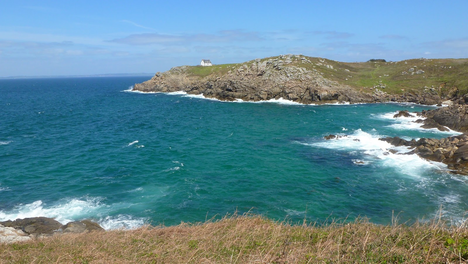
View across the river to the Île de Millocheau. At the eastern tip, a campsite. We couldn’t see whether the or not the Loire had spilled among the greenery here, though this end of the island looked particularly low lying and more exposed.

We then walked eastwards along the ridge, roughly following a section of the GR3 route along the lane at the top. Several house names pertained to windmills, such as Moulin Solaire. The road then opened out into farming country, with another vineyard. Though no windmills, two water towers. As seen with the Cargate Water Tower (see notes in April), most water towers in the UK have been torn down now. In France, they are still common. Presumably, they are to serve farms. A man with a laden donkey passed us along the lane.

When we got to the farm buildings and were roughly level with the railway bridge, We followed narrow and paths steeply down the hill to the river, following the Loire back to the Pont Cessart. We came down near the railway bridge, where there was a small park. Solo angler and dogwalkers. A St. Bernard. Upstream of the island here, it was a bit wider, the current not quite so strong. Despite the current, a pleasure boat. Though the Loire is officially navigable for the last 35 miles downstream from Nantes, where it is tidal, but that’s for modern shipping, requiring deeper water. Until the late nineteenth century, however, it was a major trading route. Strong currents, the very varied flow regime with a tendency to both drought and flood, navigation on the Loire was always difficult. Today, for its size, it’s remarkably free of boats, though there are now pleasure boats like this one, making considerably faster progress with the current than against it.

To our left along the road by the river was the tuffeau cliff in the hill, with a trogolodyte dwellings. A sign to the tank museum. Church / cathedral with large dome. This was the Notre Dame des Ardilliers.

Trogodytes, modern cave-based food cultivation and art studios

After spending the Monday morning in Saumur, we headed westwards across the Thouet to sample some of the underground culture along the Loire, at the Musee du Champignon.  This was set in a network of caves cut into the tuffeau hillside. We were able to buy a combined ticket for this and The Pierre et Lumiere (€13),  which was 300m westwards along the road. apart. Both museums were set in cave systems going well back into the hillside. The mushroom museum was particularly extensive. Both educational and also a working site, mushrooms cultivated in the cave systems to sell to shops / restuarants in Paris and well beyond. The biggest mushroom producer in France. These caves are great for cultivating mushrooms as they stay at a fairly constant temperature and high humidity through the year. Displays in French and English. In the two main displays: the myriad of mushroom varieties from all over the world, all shapes, colours and sizes, edible and toxic mushrooms (not always easy to tell the difference). Furthest back in the cave was La Champignonniere, where they cultivate mushroom. Not only in beds of soil / compost on the ground, but also in more unsual ways – grow-bags, some hanging “nougat” slabs of soil with mushrooms growing out from the sides.

Just ahead of a big coach party of French youngsters, we headed 300m westwards to the next one, the Pierre et Lumiere.

Pierre et Lumiere - Stone and Light

Here there was stone sculpture of various landmarks along the Loire and riverside towns, mainly carved in situ from the tuffeau. All viewed via a one way system through the cave network, moving up the Loire from west to east, beginning west of Angers and ending east of Tours at Amboise. It could have been twee, but wasn’t. Intricate carving involving tonnes of tuffeau, one 40 tonnes. All tastefully lit. The sculptor was Philippe Comander. Noted he started out in Brittany, carving granite, which would have been much tougher / literally harder than tuffeau. It gave us ideas for places to visit during the week. Chinon and Candes St. Martin were a must. Other highlight sculptures were: Angers – riverside view (from the Maine), ochre tint of water and sky added constrast enhancing the overall effect. Chateau and buildings. Use of Anjou slate in the chateau walls (ardoise). Angers is about where the Loire enters the harder, metamorphic / igneous terrain of the Amorican Massif. Saumur – view from a cross the Loire, plied by a sailing barge.Sculptor had to work in 95% humidity to create this. The cathedral at Tours, with its twin spires on the west front. Changing colour backlighting.  Intricate carving of stained glass windows etc.

Troglodytes dwellings along the Loire valley have various uses, among them homes, eateries, wine storage, also art studios. I'm not a sculptor and painters usually seek plenty of natural light. However, the cool, constant temperature of a cave and being able to control the light / achieve even lighting throughout the day assuming and electricity supply, without the intrusion of glare I have to contend with at home during the spring and summer appeals.

More photos from Saumur - shop and gallery windows


Around Fontevraud Abbey - 6th May


Notes from Finisterre - Part 2

Finisterre May 2015 Part 2 - Estuaries, harbours and towns


Quimper

We made two visits to Quimper, focused on the historic old town situated at the confluence of le Steïr and l’Odet, with the cathedral next to the square, timber framed buildings and several museums. The first one (11th May) was a general wander. When we returned about a week later (19th May) we enjoyed a delicious lunch in the Crêperie Quartier: a savoury crêpe for first course, followed by a dessert involving a crêpe, banana, ice cream and cream. This all filled us nicely for the rest of the day. We also visited the Musée Breton near the cathedral, particularly the exhibition of woodcuts, etchings and dry point by Breton printmakers - Nature de graveurs. A diversity of interpretations here on the various aspects of the Bretagne landscape and coast, including history, mythology, the power of the sea, the rocks, streams. I liked the series of woodcuts set on the Aven, the upper reaches where the river tumbled over rocks; the geologically inspired pieces in the first room; the depictions of wave and tide movement through relatively fine mark on a woodblock, blending to produce tone. The museum was interesting as well - pre-Roman / Roman tools, coins, granite milestones and standing stones. In later galleries, traditional Breton costume and its depiction by artists.


The town is situated at the confluence of the l’Odet (photo below)  and le Steïr (photo above).

Links to the corresponding Wikipedia français articles:

The Odet is the larger one, rising northeast of the town. The Steïr comes in from the north. It is partly culverted beneath the old town. Just upstream across the Pont Medard, where it ran alongside the cinema and car park, there was a weir. Looking back through the family photo albums from my childhood after the holiday, I recognised the view from the Pont Medard towards the old town. An interesting old building on the right with a wall overhanging the river. A flood mark on the bridge: 13 Décembre 2000 - Plus Hautes eaux connues (highest known water level). The date didn’t surprise me: it was during another rough patch of weather, with rain-bearing low pressure system after another triggering major flooding.  The Ouse reached a record level in York. The Severn flooded in early November and again around this time in December. There was flooding in Quimper again, involving both rivers during the winter 2013/14 (see overview). According to Wikipedia français, the highest mean daily flow on the Steïr in Quimper, in cubic metres per second,  was recorded on 12th December 2000 and the highest flow at any instant was during the later very stormy episode on 7th February 2014.

Of the two Quimper rivers, le Steïr was the easier river to be beside sketching etc. I don’t think I’ve seen a river with so many and so closely spaced bridges as the Odet here, but it was disappointing in that there were two busy roads running along both sides of it, with regular intersections. The noise and volume and traffic were oppressive, all the more in an incised valley along a relatively narrow river. We didn’t feel like going far, but we couldn’t immediately see any green areas / parks near the river where we could have it taken it more quietly. Instead we crossed the river and walked up the hill. There it was mainly wooded and on the edge of residential streets and not many seats, though there were a few gaps offering views of the cathedral. A passing jogger wished us Bon appétit as we ate our baguettes.

Though I didn’t notice any marked change in water levels, I gathered the Odet was still tidal through the centre of Quimper. During the first visit, it looked fairly gentle, but when I looked during the afternoon of the second visit, there was a strong current and the water looked more choppy. Below Quimper, it opens out into a wide, 20km long, estuary. Bénodet – I hadn’t twigged until now the resort takes its name from the river – is at the mouth of it, on the east bank. A flower shop along the river near the cathedral called Fleurodet.

The flooding on the Odet through Quimper Christmas 2013 – February 2014 appeared to be a combo of fluvial and tidal flooding. The hard rock Bretagne geology makes for steep incised valleys such those of the upper Odet and Steïr. As also seen in similar valleys in Devon and Cornwall, water runs off the impermeable rocks quickly, potentially provoking flash flooding. The Wikipedia français page about the Odet lists dates of other floods, including 1995 and – interestingly June 1856 when the Loire flooded (clearly another spell of rough weather).

With a few exceptions such as le Rhône, most French rivers with names ending with a “e” are feminine, e.g. la Loire, those without a “e” – le Loir, le Steïr – are masculine. When the name starts with a vowel or “H” or “Y”, it’s harder to tell – l'Indre, l'Yonne, the l'Orne, l'Huisne etc. As Odet doesn’t has no “e” at the end, I take it to be masculine.

Le Goyen - Pont-Croix and Audierne

A pleasant estuary walk between Pont-Croix and Audierne on the southwest side of Cap Sizun, done during a drier interlude between rain in the early morning and more from mid-afternoon onwards. We parked near the river at Pont-Croix, the town built on the hill on the north bank. Downstream of the road bridge the clear running River Goyen widened into an estuary. We crossed the bridge and walked to Audierne along the left bank, the path usually running above its incised valley. The tide was out, the water running between mud banks.  Given the weather, we were glad we walked on this side first as the views were better  south the east sides of the estuary had the best views. Views back to Pont-Croix with the two churches at the top of the hill. The larger spire modelled on that of Quimper cathedral.


Le Goyen, which rises to the west of Quimper flows westwards until about  two miles after Pont-Croix. It then turns southwards for the last couple of miles. Where the path dipped down in the woods to the shore, I thought I’d sketch the view across the estuary with the mud banks. I didn’t know the tide times here - it turned out that I drew in the mud banks just in time. When I started,  there was a mud bank midstream with shallow water on the nearside of it, a little egret wading into it, water about halfway up its  legs. On the far side, deeper water - and, hey, was that a tidal current running upstream, quite strongly as well? In minutes, the mud bank was covered and the little egret had taken to swimming. That explained the lack of algal scum which I was worried might affect this sort of estuary, just as it does the Hamble. There appeared to be a reasonable fluvial flow downstream as well, with springs crossing the path and flowing steeply down to the estuary at regular intervals. Also a blue square symbol marked at regular Intervals on the map along the side of the valley indicating a washhouse or pool. We passed one just before the estuary turned south. There were Gaul- Roman period archaeological remains marked on the map. This was probably further up the hill and not the a tad disappointing 2m × 1m rectangular pool we passed. It looked silted up. Springs, and lower down, tidal incursions made the path a bit muddy in places, though manageable.


The tide seemed to come in a fairly short-lived rush then settled down. Estuary generally 250m wide, though in places narrows to about 100m, therefore pinch points. Once the tide was in and the water was filling the width of the channel, it took on an emerald green colour.

Moving downstream, towards Audierne, a boat graveyard, with the remains of three craft. Strong colours with blues, oranges and rusty browns set against the vivid green of the water.

Approaching Audierne, a view of the bridge And the town houses, hotels etc. on the far side of the harbour. The area became more built up, the last bit of the path before the town running along the edge of the grounds of a grand country house set on the hillside. Just after this, we crossed the road and turned right to cross the bridge. Immediately downstream, stone / concrete structures seemingly channelling the flow though couldn't figure out why. Needless to say, everywhere closed for lunch / people having lunch. Weather beginning to deteriorate, too, though at this point only short relatively light showers.


We wandered near the harbour and towards the outlet of the Goyen. A few fishing boats, though mainly yachts and cruisers. On our right, the le Goyen hotel, restaurant busy. Car park alongside the harbour, near the working fishing boats. . Seemingly subsidence Issues here, with Cracks in the tarmac and areas fenced off. Noticed strandlines of seaweed on the slipway. The one for this afternoon's high tide was about halfway up it. It looked as if the tide was beginning to fall. Also a sparser but higher mark close to the top of the slipway. Though a sheltered harbour.

We didn't go all the way to the end of the river, but could see the outlet with a lighthouse on the west side of the harbour entrance and sandy beaches. It was windier here, with large breaking waves on the shore beyond the harbour entrance.

We walked back along the right bank spoilt somewhat by the weather, meaning we walked at a faster pace, in between sheltering beneath various trees. The path was built flat and broader on a bank. The first, past the Aqua Show aquarium and the  parking area with line of SUVs was tedious. A bit further on, a stone bridge over creek / small tributary stream on left. Then beyond this, the series of ponds eupuration (purification) – read sewage works, which have got to go somewhere. Nearing Pont-Croix, the path became a fitness / sport trail with distance markers, various exercise devices off the  path. View of Pont-Croix just before town but raining. Tried a soggy stretch.

Back at Pont-Croix, we looked round the town set on the hillside above the river, with steep cobbled alleyways which were slippery in the rain. A few artist studios. We went into the church with the larger spire. Various colourful stained glass windows, designs traditional and modern, though generally very dark inside. Outside, everywhere very quiet, and by now, we getting rather wet and tired, meaning we didn't really appreciate Pont-Croix as we might have done otherwise.

Concarneau

We went to Concarneau, to the south of Quimper on the Sunday of the middle weekend (17th May). Here, there was the fortified old town built on an small island and a working fishing port on the north side of the harbour.

There were fortified granite walls all the way around the old town. Near the bridge, a clock tower and lower, broad tower where flags from various nations were flying.  Everywhere within the confines of these walls seemed to consist mostly of eateries and souvenir shops. It was very busy and touristy, with more Brits than we’d seen anywhere else during our time away. Back near the gateway,  pan pipers. More a cliché than a Breton thing. We also spotted a food related pun Chilli Concarneau.

We preferred the views from the ramparts around the harbour, with boats reflected in the mirror-like water in the deeper water to the north. The area near the footbridge high and dry when we arrived. Lots of seaweed, though not green algal lawns. Across the harbour to the north was the working port, with hardy fishing boats and the big fish auction hall. The harbour is formed by the Moros estuary. There  appeared to be a barrage above a road bridge high above the valley. Behind the dam, what looked like a reservoir.  A passenger ferry from the east side of the old town.  


As well as the walled town, we had a more general wander on the west side of the harbour, first towards the port, from where there was a view back to the old town. Quite a bit of colour and interest in the fishing boats, though it didn't have quite the same attraction as St. Guénolé on Wednesday.

After lunch on a bench near the walled town, we  continued round to the south, past the marine biology research centre - there are far worse places to do research. A bit further round the Auberge de Jeunesse. Worse places, for a youth hostel. Views out into the Baie de Forêt, with beacons going out into the distance. Water calm in the still, anticyclonic weather. Near here, too - across the road from the water, the Port de la Croix lighthouse and the Quai Russe, pier named after a Russian ship running aground c.1904, supplying much needed but otherwise useless cement tainted with sea water. It came in handy for building the protective quay and improved Franco-Russian relations for a little while.

After a shortcut back through the streets from the Port de la Croix area, returned to the old town and drew boats from one of the seats on the middle north facing tower. Tide by now coming in slowly, fish beneath the footbridge. What I will say for the busy walled town was the ice creams were great. At least two outlets, selling scoops of various flavours in generous size wafer cones. Spoilt for choice of flavours and ended up getting more ice cream than we bargained for, thanks to Franglais communication breakdown. Instead of two single scoops in separate cones, we got doubles. Proportionally not much more expensive either.

Menez-Hom and the Aulne

Menez-Hom, 330m, was the highest point in the area, situated at the eastern end of the Presqu'Île de Crozon, the middle peninsula of Finisterre. We parked at the top and, once the initial localised showers had passed over, we admired the views all round: east  and inland to the Monts d'Arrée. Cap Sizun was to the south, across the  Baie de Douarnenez with Pointe du Van at the far end and Douarnenez at eastern end of bay. The Presqu'Île de Crozon stretched to the west with Cap de la Chevre at its far western end. To the north was the estuary of River Aulne, with suspension bridge near western end, the Pont de Térénez. Over the hill beyond it, a glimpse of the Rade de Brest, the  natural harbour / sound between the Presqu'Île de Crozon and the Brest peninsula. The built up area of Brest was on the far NW horizon, a tower with a white dome on the ridge to the east – radar / observatory?


Menez-Hom is very popular with hang gliders and model aeroplane enthusiast. There was a sign near car park, with rules for model aeroplane flying, in French and English. Apparently flying model planes  above 1000ft is forbidden, therefore not on the top of the hill (1082ft) or too close to other people. Most of them were on the ridge lower down, facing north / northwest.

Having admired the views, we walked down the hill to Aulne at Trégarvan, and all the back up again from sea level. We began on the east side of the hill and then followed a path north to the lane. We then took various minor paths / tracks down towards the Aulne, through the Forêt de Communale Trégarvan. For the last bit down to the river we followed a stream tumbling among the rocks, downhill to a muddy looking creek, the Ster du Pont Men. The path then turned right and followed Aulne for a short while above it to Trégarvan. There were glimpses of the suspension bridge, though the trees blocked the best of the views. At Trégarvan, the path opened out onto the road past the quay with a slipway.  We had our baguettes on the picnic table. The estuary was now mostly mud, the tide ebbing, quickly revealing mud banks either side. The tidal range looked fairly high. A very recent looking strandline of debris very hear the top of the slipway and quay wall. Spring tides about now, with new moon on Monday though average ones rather than exceptional. A few yachts, some of them quickly being left high and mud bound as the tide retreated.

The tidal limit of the Aulne is at Châteaulin from where it forms the western end of the Canal de Nantes a Brest. This stretch is very sinuous with tight incised meander. According to Wikipedia français, the name of the river has much the same root as that of the various River Avons in the UK. It is 140km long. The canal is seemingly a mixture of proper canal linking various rivers between the Aulne and Erdre at Nantes.


Began the plod back up the hill by following road up from the quay past the houses alongside the road to the church. There, there was a jam-packed graveyard with some various ostentatious looking tombstones. A mix of older, more weathered crucifix designs near the eastern end and very new looking ones of freshly polished granite near the western end. Next to the church a gateway to house number Zero, a witch on broomstick weather Vane on top of it.


Leaving Trégarvan, we followed the road up hill. There must have been something on nearby as it seemed exceptionally busy. I was glad when we turned left, off it. We then had some good views along the Aulne to the east of Trégarvan. A signpost to Kergantic. 


Otherwise it was a tedious long slog. Not helped by  the path dipping  down before going back up again. As on the way down, no direct path, but a fiddly mix of roads, tracks, minor paths. The lower bit was mainly through woods and fairly tedious. We were on the sheltered side of the hill, out of the wind, particularly lower down. Though it wasn't a hot day, I still had to take off and carry my outer layers, including the purple rain / windproof needed for the top of the hill but heavy and bulky to carry. Even though not that much else in it, rucksack felt heavier than usual. Later, as the slope steepened towards the ridge, the path opened out. The woodland here was much less dense and there were still signs of the forest fire which badly burned the NE slopes of the hill in June 2006. There were quite a few dead trees, mainly pines, dead or growing but bark still charred. That had been another hot, dry summer, with drought issues both sides of the Channel. The shortcut up onto the ridge from here was rather muddy. I’m glad we’d admired the views when we’d arrived as there was a large group of people monopolising the panorama when we got to the top.

Douarnenez

Visited on the last day of our holiday as a change of plan: we had set out for another walk on the north coast of Cap Sizun, near the bird reserve, hoping the drizzle and mist would clear. By mid-morning – later than usual, it wasn’t so we turned round and headed east. It seemed this murkiness came in with anticyclone building off the Bay of Biscay from the middle of the week. By midday, as we explored Douarnenez, it lifted and the sun came out, though the top of Menez-Hom, across the Baie de Douarnenez, was shrouded in cloud all day.

Douarnenez  was a mix of working port, historic  and pleasure port, beaches, and the town up the hill where there were some artists’ studios. Various boats in the Port Rhu area - some historical ones colourfully painted. A light ship. There was the boat museum in this area as well, though we didn’t go in. 


The harbour here was a creek at the outlet of a small stream, dam at southern head of the creek where the road was. A lock  with a swing bridge at the seaward end forming a calm harbour for reasonable size boats (18m length). Beyond the lock, towards the bay, a small beach and harbour. An island with building relating to former sardine trade at Douarnenez. The town centre was up the hill. Though light compared to English towns, the traffic that there was here was tiresome, particularly along the narrower streets down towards the harbour. The working port was to the east, with blue gasometers near the road painted with shoals of fish. Lunch on bench at the Port / Plage Rosmeur. We walked along both sides of the Port Rhu creek, though the east side with the boat museum was the more attractive one. On the west side blocks of flats. Back on the other side, upstream of the road bridge, working boatyards. View beyond the yachts to a cimetière de bateau (boat graveyard) on the far side.


Notes from Finisterre Part 1 - Coast, waves and weather

South Finisterre  9th - 23rd May 2015


More sketches from Finisterre on my Water and Art pages:
http://artywater.blogspot.co.uk/2015/06/holiday-sketches-part-2-finisterre.html?view=timeslide

Holiday Sketches Part 3 – Estuaries, harbours and towns


Three beaches along the Baie d’Audierne  


The first of these (le Gored west of Plozévet) was straight after our journey to Finisterre on 9th May. This was a good introduction to the hard, mainly crystalline rock geology here. My knowledge of French geology is not as good as that of the UK, but much of the geology of Brittany and the Amorican Massif underlying western France has been shaped by three continental collisions. The first one during the Neoproterozoic era c 600Ma, the second and third ones were the Caledonian and Hercynian (Variscan) orogenies during the Palaeozoic, as the components of Pangaea supercontinent came together. This has all resulted in extensive igneous intrusion (granites) and deformation – alteration of sediments under heat and pressure (metamorphism) such as schists and sheering. The layers (sedimentary bedding planes and foliation) in the low cliffs and wave cut platforms on this beach and the one we visited the following day (Porzambréval, almost nextdoor, 10th May) showed a consistent, distinctive roughly east – west alignment. Any sedimentary beds were steeply dipping, almost vertical in places.


At low tide rock pools in the platform. Among the birdlife, a comorant and little egret.
Eastwards along the coast, a marshy area, drained by streams. Got across the first one As there was a bridge and it was relatively narrow. Yellow irises along its banks. Second one, though, much wider and deeper, tumbling as it ran down the sloping backshore. No bridge near the beach, so couldn't go any further. Took these streams to be formed from springs. Though the bedrock is crystalline and impermeable, I believe there are fractures which hold water, forming an aquifer. There were wells marked on the map. As no bridge over the second one, took this to mean it was well topped up and flowing more copiously than usual.

After a slower paced morning at the cottage at the end of the first week (15th May) we went to Penhors which was about midway along the Baie d’Audierne. Car park busy, though at least to begin with, very few people on the beach. This was because the tide was in and the beach was being pounded by waves of considerable force. A few brave surfers. To the south, the more distant end of the beach a mass of white foam and sea spray. Near the car park, the waves crashed over a low seawall, two of them with a gap. Take it these walls were to dissipate at least some of the wave energy in that particular bit of beach-the waves having eaten into the cliff forming a small bay. At either end were banks of granite rock armour. The cliffs here were low, generally no higher than about 3m. The upper metre or so was unconsolidated loess, making them particularly vulnerable to erosion. In places, the GR34 path was getting close to the edge, some of the houses not that far off either. More rock armour. To the north, the cliffs gave way to shingle and a small lagoon like those we'd seen further along the Baie d 'Audierne last weekend. Once again, no way across the outlet. Part of the backshore fenced off far birds laying eggs on the shore. At the edge of the lagoon, a group of large gulls and a cormorant with its wings opened out. Sketched the waves, sat on the shingle.

Pointe du Raz and Pointe du Van

Pointe du Raz from Pointe du Van
These are the most westerly points on the mainland of southern Finisterre with the Baie de Trépassés between them. We visited Pointe du Raz, the more southerly one, during the middle of the first week, beginning by walking round to the point from Bestree. Here, there was a small harbour, reached by a very steep slipway and a lift down from the end of the lane above the cliff with a crane. Built originally service the lighthouses just off the Point. It was formed by a line of rocks, with two sections of concrete wall filling the gaps. Though very sturdy looking, this wall has been breached by the waves several times during storms. On this particularly exposed stretch of coast, the south side of the Point is about as sheltered as it gets.  


From there, there was a short but tricky, narrow stretch of path with sheer drops to our left. It opened out near the Pointe, but we really had to concentrate and watch our footing. It was a bright day, with superb visibility. The Point itself was a gradually tapering area of granite, with rock outcrops just offshore. Behind us was the Semaphore tower for safe navigation, in front of this a Mary figure - Notre-Dame-des-Naufrages, Our Lady of the Shipwrecked. Two lighthouses, La Vieille the nearest, with slanting blocky stone design. Beyond these was the low lying Île de Sein, with its own long narrow lighthouse on the north side.  Far out to sea beyond the island was the especially exposed Phare Ar Men.


The Raz at Pointe du Raz was the Raz de Sein, between the Pointe and the Île. The waves and currents here are especially treacherous, with tidal currents of the order of 7 knots according to the display in the visitor centre.  We were here on a calm day with very 5kph winds and a neap tide. Even so the waters here were very turbulent, with white breakers, especially around the rock outcrops with the lighthouses. Seagulls in their wake. Several boats braving them. Some impressive Youtube footage of stormy seas here, with waves exceeding 10m and overtopping the lighthouses.

It was very busy on the Pointe, this being one of the key attractions in this area, though the crowds thinned notably at lunchtime.


To the north of the Point was the Baie de Trépassés. On the far side of it, the Pointe du Van. In the distance beyond it, the next Finisterre peninsula northwards. We may have seen the western end of the Brest peninsula which sticks out westwards beyond it.

The north side was relatively sheltered, with a the sandy beach. We walked to far southern end of this along the coast path, enjoying the vivid greens of the sea nearer the shore, the energy and white water wave patterns as waves broke on the shore / over the rock outcrops. Some interesting wave patterns as the water shallowed towards the sandy beach.


We looked round the Pointe du Raz visitor centre after we had walked back up the cliff. It was striking to compare and contrast the management of Pointe du Raz to England’s Lands End. The latter wasn’t too bad when I visited as a child in the late 1970s, when there was just the signpost. By the early 1990s, however, it had been ruined by commercial development in the form of a theme park and shopping area.  Since 2004, Pointe du Raz has been one of France's National Sites which are given special protection. This was one of a number of steps taken during the past few decades to protect the area from environmental damage, including tourist erosion, and intrusive commercial development. The car park is now 800m from the Point (shuttle bus if wanted). This was the only place throughout our holiday when we had to pay for parking (six euros) but we didn’t mind as it went towards the upkeep of the site. Given all these improvements, I was astonished to learn at the visitor centre that they very nearly went and built a nuclear power station just along the road at Plogoff. The locals were up in arms –literally. A photo from 1980 of people clad in metal armour brandishing shields. Thankfully, the powers that were back then listened and nothing came of it.

We visited Pointe du Van towards the end of our second week. As the day went on, it became more hazy / misty, but when we arrived, it was bright and clear, with views back to Pointe du Raz and westwards beyond the Ile-de-Sein where the houses and lighthouses caught the light. To the north was  the Presqu'Île de Crozon and western tip of the Brest peninsula beyond it. Above the cliff was a chapel and a stone structure housing a fountain, presumably a spring, though any upwelling pretty paltry and subsumed by green algal gunk. We did a short walk rounding the Pointe du Van to the next headland on the north coast, the du Castelmeur. Another stretch of coastline with sheer cliffs and the path was narrow in places, though it wasn’t as busy as at Pointe du Raz. The rocks here seemed to be more mixed, with resistant granite nearer the Pointe du Van and steeply dipping, less resistant bedded rock on the . In places, there had been slippages, Some slate-like rock on one cliff lower down.

Point de Penmarc’h

This was the headland at the southern end of the Baie d’Audierne. Pointe du Raz was visible at the far western end. This Pointe was very different to those on the north and western coasts: it was built up, with an interest mix of lighthouses, beacons and working harbours with fishing boat making for an interesting mix of sketching material.  We made two visits here, parking next to the Phare Eckmühl, the taller of the two lighthouses and furthest inland at the Pointe, built in 1897. In front of it was le Vieux Phare (the old lighthouse) which now housed a small museum and art gallery. Nearest the rocky shore was a semaphore / coastguard station and a C15th church immediately behind it. Some colourful snail shells on the shore here. Next to the car park, a small park with an installation comprising various funnels to speak into and listen to what came out. They were about the trans-Atlantic cable terminus here.


On our first visit (13th May) we walked north from the lighthouses to the working harbour at St. Guénolé and the more massively rocky granite shore beyond it, following the GR34. I liked this bit of coast for all the lighthouses and beacons, though I preferred everything during the morning, before the cloud cleared. The colours were stronger. When the sun came out later the light was a bit harsh. By then, too, the tide was further out, exposing lots of smelly seaweed on the wave cut platform either side of the lighthouses. Though there was more of a mix of seaweed species than the green scum afflicting the Hamble etc., the smell stayed with me like an after-taste all the time we were looking round the museum and even, for a while, back at the cottage. In Brittany, they harvest seaweed for use as fertiliser, though the blooming algae can go too far, just as it does back home. I gather it’s worst along the north coast, which says something about the water quality of the English Channel.


In the harbour at St. Guénolé were various size boats from smaller cruisers to the heavy duty fishing boats near the warehouses. One of these, appropriately for a granite coast, was called Pluton.  A lifeboat and lifeboat station. To our eyes, the random colourful blobs of paint decorating the walls near the path round the edge of the port were reminiscent of some forms of abstract art. A selection of signs and notices noticed, mainly relating to the port and the sea.

Round from the port was the Plage de Pors Carn. Here, shore was very rocky with massive boulders of granite. The shapes these formed were interesting, but it was all steeply shelving and prone to big powerful waves and swells. All the warning notices about dangerous waves (vagues) and risk of drowning (noyade), even when the sea is calm suggested this stretch of coast was dangerously deceptive. I hope the authors of the youtube footage here during the storms the winter before last were being careful.

Just beyond here, the backshore opened out, with some older, potentially very exposed buildings. A view across the Plage to Pointe de la Torche. Beyond this, the Plage de Tronoan, the long sandy beach running along the southern end of the Baie d'Audierne, its bright sand showing up strongly as the sky began to brighten. Apparently bathing is dangerous here, too. When we saw the waves at Penhors two days later, we got a fairly good idea why.

After walking back to the Pointe, we had a look round the museum and art exhibition in the Vieux Phare, though we decided against the Phare Eckmühl as didn't fancy the vertigo-inducing steep, long, narrow spiral staircase. In the museum, a display about lighthouses: the evolution of lamps from basic wood fires to Incandescent bulbs set in arrays of parabolic lenses to focus amplify the beam. A selection of gas / oil lamps, big incandescent bulbs, associated tools. Photos showed the development around the Pointe, including construction of this lighthouse; the evolution of the harbour at St. Guénolé, the various beacons. As usually happens, everywhere became progressively more built up.  Saw from one of the later photos at Penmarc'h (1980 and after) some beach on the SE side of the lighthouses reclaimed and built on, having previously been a seaweed harvesting site.

On the first floor of the Vieux Phare, an unusual at exhibition space, now housing an exhibition of paintings by Henry Kérisit depicting sailing boats. A mix of drawings, paintings in gouache, ink and wash, along with collages on canvas / linen. I liked the simple boat and sail forms in the collages. The boat portraits much more precise and more illustrative.  The portraits of Portuguese barges were interesting for the different design of the vessels compared to more familiar northern European barges: a more curved form. Their colourful decoration was reminiscent of UK canal boats. Views through the windows out to the shore were pictures in themselves.

Our second visit (18th May) was for a few hours during the middle of the day, after postponing Menez-Hom (see Estuaries, harbours and towns) because of the rain, drizzle and mist. It was murky out to sea, the showers were coming and going. During an early lunch, I tried sketching the Vieux Phare from the car, though windows quickly steamed up. I then went outside, where I could see over the wall and had a go at sketching the view to the north, towards St. Guénolé with the two black and white striped beacons in the middle distance. The tide was now well out, revealing a broad wave-cut platform comprising low, rounded granite rocks / boulders interspersed with lots of seaweed and a few pools. It was very blowy and I forgot to bring a buff or scarf, so my hair blew everywhere. As usual, l worked with Inktense water soluble pencils and dual tip brush pens. The lighthouse offshore from St. Guénolé disappeared into the murk. When it got a bit damper, I cowered behind the wall and carried on, meaning l didn't see the short but sharp shower coming. I dashed into the car just in time, before everything onto page ran into a sodden, soggy mess. Actually, I hit the sweet spot – just enough soaking to loosen everything up by allowing the colours to blend wet-into-wet. I dabbed a few bits, then left my sketchbook to dry on the backseat of the car while I went and joined my other half at the harbour at Kerity to the south of the lighthouses as the rain eased off. No more showers after that one.


There, we walked out onto both the piers at the harbour, beginning with the longer, more easterly one. Views east towards le Guilvinec and the fishing port there. Les Etocs rocks offshore to the south. On the seafront near the piers, a restaurant named after them. The tide was now beginning to come in, quickly covering, the wave-cut platform. There were subtle but noticeable currents in the shallow water near the piers, interplaying with the water movement in the wind. Presumably, the currents arose from water flowing between the rocks as the tide rounds the Pointe de Penmarc'h.


Back at the car, sketchbook now dry, I drew the Phare Eckmühl. On our way back round the lighthouses, we spotted a barometer on east side of the Vieux Phare. The pressures on the gauge ranged from 920 millibars up to 1070 millibars. Both these extremes were beyond the all-time highs and lows recorded in north western Europe. The accompanying weather ranged from Tempête (storm) near the lower end, then Pluie ou vent (rain or wind), to beau temps (fine weather) and Très Sec (very dry)at the highest pressures.


Cap Sizun north coast – Pointe du Millier


Visited during the middle weekend (16th May). We parked bear Pointe de Millier and walked from there to the next headland westwards, the Pointe de Trenaouret. A grey, at first drizzly start, but the sky cleared around late morning. The rest of the day and evening were sunny. First, we had a quick look at Pointe du Millier near the lighthouse. Certainly from behind, it looked more like a house than a lighthouse, semi-circular tower with the light being built into the seaward facing wall of the house.  

We then had a look at the watermill, the moulin a eau in the small steep valley to the SE of the Pointe. The wooded valley here was very lush and moist. Below the mill, a stream divided into rivulets and flowed down the slope. Above it, it was channelled into a narrow conduit running directly to the water wheel on the west side. It was a large wheel, wider than the two storeys of the stone building / slate roof. It was turning as the stream was flowing well. A spring-fed stream? A few small seasonal streams marked on the maps in the Cap Sizun area, usually uppermost reaches.

From the mill, we rejoined the coast path and walked westwards. Stopped to sketch at the small sandy beach called the Plage de Pors Peron. Just round the cliff to the west was a small, inaccessible cove. Path then climbed steeply up again, then down again to a small inlet with a slipway. Memorial plaque on right, August 1943.

Lunch on the Pointe de Trenaouret, looking back towards Pointe du Millier, as it was a bit chilly, blowy on the west side of the Pointe. Some vocal small birds about. Nests among the bracken, gorse etc., perhaps. A mix of rounded granites, especially at the headlands and more blocky / bedded rock apparently dipping upwards of 45 degrees.


Les Tempetes d’Hiver 2013 - 2014

Like much of the UK Brittany took a hammering during the seriously, serially stormy winter December 2013 – February 2014. At the time I was too wrapped up in what was going on this side of the Channel to follow it, by all accounts the effects of gale force winds, heavy seas, high tides, coastal and fluvial flooding were all just as bad. Firstly, there was the Tempête Noël, aka Cyclone Dirk, the exceptionally deep low pressure system which brought the damaging, disruptive gales just before Christmas 2013. There was bad flooding in Morlaix on the NW coast. In Quimper on Christmas Day, the Odet was rising and at Châteaulin the Aulne transformed into a raging torrent. Come the new year, warning maps from Météo France pointing to the same high tides which prompted the severe flood warnings on the Severn (beginning of January and February). The exposed western and northern coasts, notably Pointe du Raz and St. Malo were pounded by waves, some exceeding 10m. There was flooding along la Vilaine, the longest river in Brittany, around Redon, along with further, repeated episodes of débordement in Châteaulin and Quimper –Le Steïr sort de son lit (out of bed) in one youtube video, the town bracing itself as the Odet rose during the first week of February. 

Like the same storms in the UK, it all generated plenty of youtube footage. These are links to a selection of it: