
More sketches from Finisterre on my Water and Art pages:
http://artywater.blogspot.co.uk/2015/06/holiday-sketches-part-2-finisterre.html?view=timeslide
Holiday Sketches Part 3 –
Estuaries, harbours and towns
Three beaches along the Baie d’Audierne


At low tide rock pools in the platform. Among the birdlife, a
comorant and little egret.
Eastwards
along the coast, a marshy area, drained by streams. Got across the first one As
there was a bridge and it was relatively narrow. Yellow irises along its banks.
Second one, though, much wider and deeper, tumbling as it ran down the sloping
backshore. No bridge near the beach, so couldn't go any further. Took these
streams to be formed from springs. Though the bedrock is crystalline and
impermeable, I believe there are fractures which hold water, forming an
aquifer. There were wells marked on the map. As no bridge over the second one,
took this to mean it was well topped up and flowing more copiously than usual.

Pointe du Raz and Pointe du
Van
 |
| Pointe du Raz from Pointe du Van |

From there, there was a short but tricky, narrow stretch of path with sheer drops to our left. It opened out near the Pointe, but we really had to concentrate and watch our footing. It was a bright day, with superb visibility. The Point itself was a gradually tapering area of granite, with rock outcrops just offshore. Behind us was the Semaphore tower for safe navigation, in front of this a Mary figure - Notre-Dame-des-Naufrages, Our Lady of the Shipwrecked. Two lighthouses, La Vieille the nearest, with slanting blocky stone design. Beyond these was the low lying Île de Sein, with its own long narrow lighthouse on the north side. Far out to sea beyond the island was the especially exposed Phare Ar Men.

The Raz at Pointe du Raz was the Raz de Sein,
between the Pointe and the Île. The waves and currents here are especially
treacherous, with tidal currents of the order of 7 knots according to the
display in the visitor centre. We were
here on a calm day with very 5kph winds and a neap tide. Even so the waters
here were very turbulent, with white breakers, especially around the rock
outcrops with the lighthouses. Seagulls in their wake. Several boats braving
them. Some impressive Youtube footage of stormy seas here, with waves exceeding
10m and overtopping the lighthouses.
It was very busy on the Pointe, this being one of
the key attractions in this area, though the crowds thinned notably at
lunchtime.

To the north of the Point was the Baie de Trépassés.
On the far side of it, the Pointe du Van. In the distance beyond it, the next
Finisterre peninsula northwards. We may have seen the western end of the Brest
peninsula which sticks out westwards beyond it.
The north side was relatively sheltered, with a the
sandy beach. We walked to far southern end of this along the coast path, enjoying
the vivid greens of the sea nearer the shore, the energy and white water wave
patterns as waves broke on the shore / over the rock outcrops. Some interesting
wave patterns as the water shallowed towards the sandy beach.


Point de Penmarc’h


On our first visit (13th May) we walked
north from the lighthouses to the working harbour at St. Guénolé and the more
massively rocky granite shore beyond it, following the GR34. I liked this bit
of coast for all the lighthouses and beacons, though I preferred everything
during the morning, before the cloud cleared. The colours were stronger. When
the sun came out later the light was a bit harsh. By then, too, the tide was
further out, exposing lots of smelly seaweed on the wave cut platform either
side of the lighthouses. Though there was more of a mix of seaweed species than
the green scum afflicting the Hamble etc., the smell stayed with me like an
after-taste all the time we were looking round the museum and even, for a
while, back at the cottage. In Brittany, they harvest seaweed for use as
fertiliser, though the blooming algae can go too far, just as it does back
home. I gather it’s worst along the north coast, which says something about the
water quality of the English Channel.
 In the harbour at St. Guénolé were various size
boats from smaller cruisers to the heavy duty fishing boats near the warehouses.
One of these, appropriately for a granite coast, was called Pluton.
A lifeboat and lifeboat station. To our eyes, the random colourful blobs
of paint decorating the walls near the path round the edge of the port were
reminiscent of some forms of abstract art. A selection of signs and notices
noticed, mainly relating to the port and the sea.
In the harbour at St. Guénolé were various size
boats from smaller cruisers to the heavy duty fishing boats near the warehouses.
One of these, appropriately for a granite coast, was called Pluton.
A lifeboat and lifeboat station. To our eyes, the random colourful blobs
of paint decorating the walls near the path round the edge of the port were
reminiscent of some forms of abstract art. A selection of signs and notices
noticed, mainly relating to the port and the sea.

Round from the port was the Plage de Pors Carn.
Here, shore was very rocky with massive boulders of granite. The shapes these
formed were interesting, but it was all steeply shelving and prone to big
powerful waves and swells. All the warning notices about dangerous waves
(vagues) and risk of drowning (noyade), even when the sea is calm suggested
this stretch of coast was dangerously deceptive. I hope the authors of the
youtube footage here during the storms the winter before last were being
careful.
Just beyond here, the backshore opened out, with some
older, potentially very exposed buildings. A view across the Plage to Pointe de
la Torche. Beyond this, the Plage de Tronoan, the long sandy beach running
along the southern end of the Baie d'Audierne, its bright sand showing up
strongly as the sky began to brighten. Apparently bathing is dangerous here,
too. When we saw the waves at Penhors two days later, we got a fairly good idea
why.
After walking back to the Pointe, we had a look
round the museum and art exhibition in the Vieux Phare, though we decided
against the Phare Eckmühl as didn't
fancy the vertigo-inducing steep, long, narrow spiral staircase. In the museum,
a display about lighthouses: the evolution of lamps from basic wood fires to
Incandescent bulbs set in arrays of parabolic lenses to focus amplify the beam.
A selection of gas / oil lamps, big incandescent bulbs, associated tools. Photos
showed the development around the Pointe, including construction of this
lighthouse; the evolution of the harbour at St. Guénolé, the various beacons.
As usually happens, everywhere became progressively more built up. Saw from one of the later photos at Penmarc'h
(1980 and after) some beach on the SE side of the lighthouses reclaimed and
built on, having previously been a seaweed harvesting site.
On the first floor of the Vieux Phare, an unusual at
exhibition space, now housing an exhibition of paintings by Henry Kérisit depicting
sailing boats. A mix of drawings, paintings in gouache, ink and wash, along
with collages on canvas / linen. I liked the simple boat and sail forms in the
collages. The boat portraits much more precise and more illustrative. The portraits of Portuguese barges were
interesting for the different design of the vessels compared to more familiar northern
European barges: a more curved form. Their colourful decoration was reminiscent
of UK canal boats. Views through the windows out to the shore were pictures in
themselves.


There, we walked out onto both the piers at the
harbour, beginning with the longer, more easterly one. Views east towards le
Guilvinec and the fishing port there. Les Etocs rocks offshore to the south. On
the seafront near the piers, a restaurant named after them. The tide was now
beginning to come in, quickly covering, the wave-cut platform. There were subtle
but noticeable currents in the shallow water near the piers, interplaying with
the water movement in the wind. Presumably, the currents arose from water
flowing between the rocks as the tide rounds the Pointe de Penmarc'h.
 Back at the car, sketchbook now dry, I drew the Phare
Eckmühl. On our way back round the lighthouses, we spotted a barometer on east
side of the Vieux Phare. The pressures on the gauge ranged from 920 millibars
up to 1070 millibars. Both these extremes were beyond the all-time highs and
lows recorded in north western Europe. The accompanying weather ranged from Tempête (storm) near the lower end, then
Pluie ou vent (rain or wind), to beau temps (fine weather) and Très Sec (very dry)at the highest
pressures.
Back at the car, sketchbook now dry, I drew the Phare
Eckmühl. On our way back round the lighthouses, we spotted a barometer on east
side of the Vieux Phare. The pressures on the gauge ranged from 920 millibars
up to 1070 millibars. Both these extremes were beyond the all-time highs and
lows recorded in north western Europe. The accompanying weather ranged from Tempête (storm) near the lower end, then
Pluie ou vent (rain or wind), to beau temps (fine weather) and Très Sec (very dry)at the highest
pressures.

Cap Sizun north coast –
Pointe du Millier
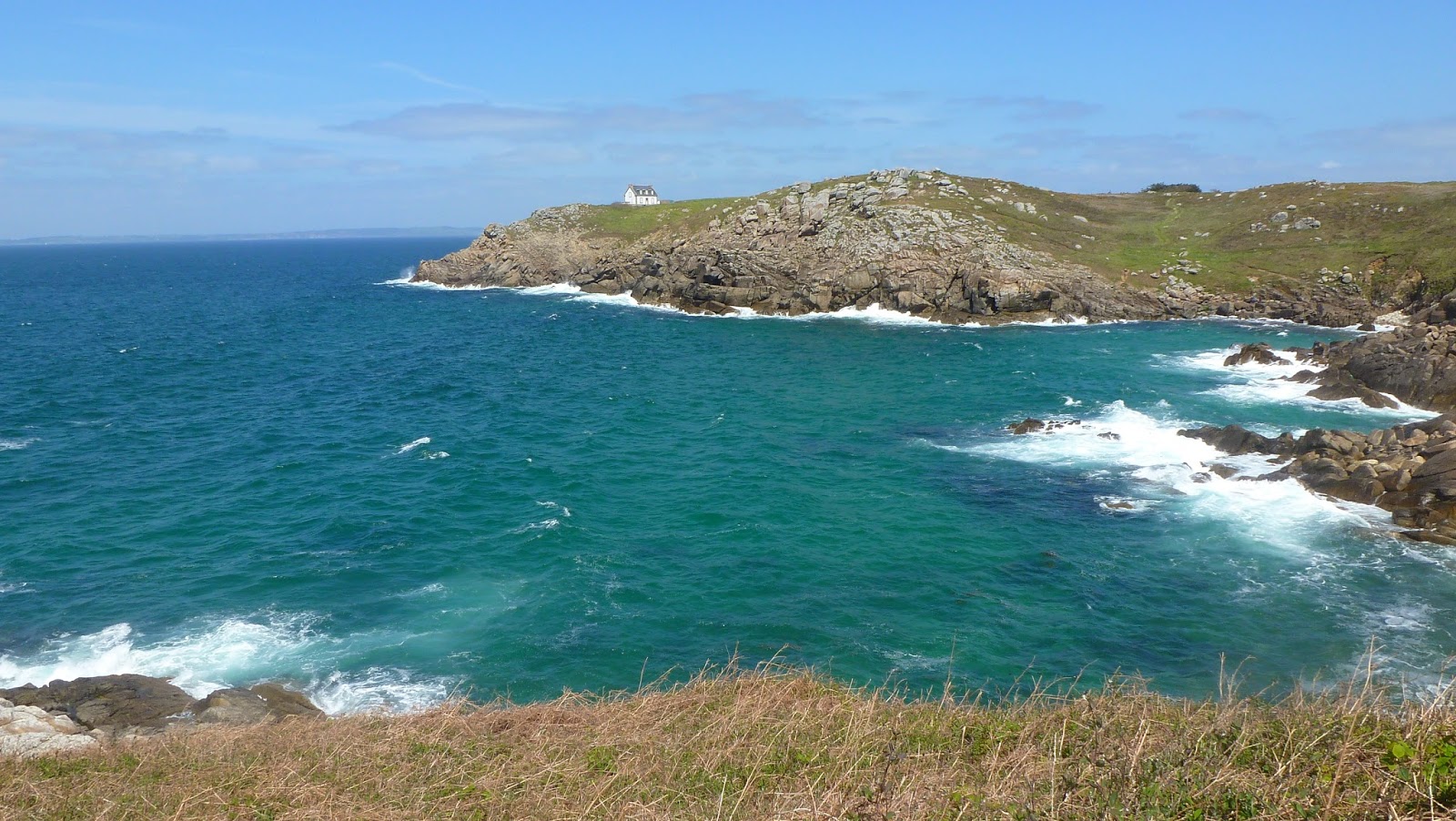
Visited during the middle weekend (16th May). We parked bear Pointe de
Millier and walked from there to the next headland westwards, the Pointe de
Trenaouret. A grey, at first drizzly start, but the sky cleared around late
morning. The rest of the day and evening were sunny. First, we had a quick look
at Pointe du Millier near the lighthouse. Certainly from behind, it looked more
like a house than a lighthouse, semi-circular tower with the light being built
into the seaward facing wall of the house.

From the mill, we rejoined the coast path and walked
westwards. Stopped to sketch at the small sandy beach called the Plage de Pors
Peron. Just round the cliff to the west was a small, inaccessible cove. Path
then climbed steeply up again, then down again to a small inlet with a slipway.
Memorial plaque on right, August 1943.

Les Tempetes d’Hiver 2013 - 2014
Like much of the UK Brittany took a hammering during the
seriously, serially stormy winter December 2013 – February 2014. At the time I
was too wrapped up in what was going on this side of the Channel to follow it, by
all accounts the effects of gale force winds, heavy seas, high tides, coastal
and fluvial flooding were all just as bad. Firstly, there was the Tempête Noël, aka Cyclone Dirk, the
exceptionally deep low pressure system which brought the damaging, disruptive
gales just before Christmas 2013. There was bad flooding in Morlaix on the NW
coast. In Quimper on Christmas Day, the Odet was rising and at Châteaulin the
Aulne transformed into a raging torrent. Come the new year, warning maps from Météo
France pointing to the same high tides which prompted the severe flood warnings
on the Severn (beginning of January and February). The exposed western and
northern coasts, notably Pointe du Raz and St. Malo were pounded by waves, some
exceeding 10m. There was flooding along la Vilaine, the longest river in
Brittany, around Redon, along with further, repeated episodes of débordement in
Châteaulin and Quimper –Le Steïr sort de son lit (out of bed) in one youtube video,
the town bracing itself as the Odet rose during the first week of February.
Like the same storms in the UK, it all generated plenty of youtube footage. These are links to a selection of it:
Like the same storms in the UK, it all generated plenty of youtube footage. These are links to a selection of it: